WARNING TO USERS OF THIS SYSTEM
This computer system, including all related equipment, networks, and network devices (including Internet access), is provided by the Department of the Interior (DOI) in accordance with the agency policy for official use and limited personal use.
All agency computer systems may be monitored for all lawful purposes,
including but not limited to, ensuring that use is authorized, for management of the system, to facilitate protection against unauthorized access, and to verify security procedures, survivability and operational security. Any information on this computer system may be examined, recorded, copied and used for authorized purposes at any time.
All information, including personal information, placed or sent over this system may be monitored, and users of this system are reminded that such monitoring does occur. Therefore, there should be no expectation of privacy with respect to use of this system.
By logging into this agency computer system, you acknowledge and consent to the monitoring of this system. Evidence of your use, authorized or
unauthorized, collected during monitoring may be used for civil, criminal, administrative, or other adverse action. Unauthorized or illegal use may subject you to prosecution.
 Name Last modified Size Description
![[PARENTDIR]](/icons/back.gif) Parent Directory -
Parent Directory -
![[ ]](/icons/layout.gif) 2011 Indiana Statewide_Ground Control Report.pdf 2020-12-04 16:52 71M
2011 Indiana Statewide_Ground Control Report.pdf 2020-12-04 16:52 71M
![[TXT]](/icons/text.gif) BESTUSE_East.xml 2020-12-04 16:52 26K
IN_2011_Statewide_East_Breakline.txt 2020-12-04 16:52 26K
IN_2011_Statewide_East_Breakline.xml 2020-12-04 16:52 27K
IN_2011_Statewide_East_IMG_DEM.txt 2020-12-04 16:52 25K
IN_2011_Statewide_East_IMG_DEM.xml 2020-12-04 16:52 26K
IN_2011_Statewide_East_LAS.txt 2020-12-04 16:52 26K
IN_2011_Statewide_East_LAS.xml 2020-12-04 16:52 27K
IN_YearOne_LiDAR Report_FINAL November 2011.pdf 2020-12-04 16:52 2.6M
BESTUSE_East.xml 2020-12-04 16:52 26K
IN_2011_Statewide_East_Breakline.txt 2020-12-04 16:52 26K
IN_2011_Statewide_East_Breakline.xml 2020-12-04 16:52 27K
IN_2011_Statewide_East_IMG_DEM.txt 2020-12-04 16:52 25K
IN_2011_Statewide_East_IMG_DEM.xml 2020-12-04 16:52 26K
IN_2011_Statewide_East_LAS.txt 2020-12-04 16:52 26K
IN_2011_Statewide_East_LAS.xml 2020-12-04 16:52 27K
IN_YearOne_LiDAR Report_FINAL November 2011.pdf 2020-12-04 16:52 2.6M
![[ ]](/icons/unknown.gif) Indiana's_Ortho_LiDAR_acquisition_Woolpert.doc 2020-12-04 16:52 614K
Indiana's_Ortho_LiDAR_acquisition_Woolpert.doc 2020-12-04 16:52 614K
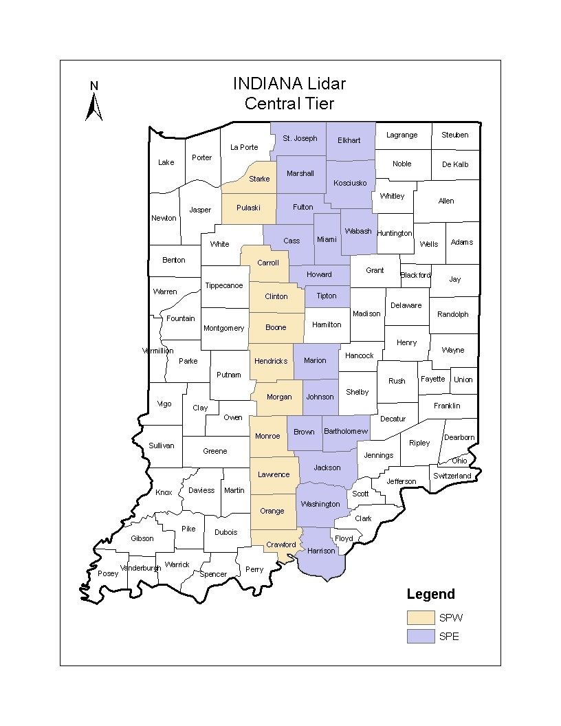
![[IMG]](/icons/image2.gif) Indiana_CentralTier_lidar.JPG 2020-12-04 16:52 225K
Woolpert_Scope_of_Services_for IN Statewide LiDAR Ortho Program.pdf 2020-12-04 16:52 6.1M
Indiana_CentralTier_lidar.JPG 2020-12-04 16:52 225K
Woolpert_Scope_of_Services_for IN Statewide LiDAR Ortho Program.pdf 2020-12-04 16:52 6.1M